Robbs Peak Northern Loop Notes
Copyright © 1999 by Jeff Robinson . You are free to use and reproduce this description for personal, not-for-profit, and not-for-business use. Any reproduction other than for personal use, including businesses, organizations, and any other profit making activities require written permission from the author ( jeffs_trails@bigfoot.com , http://www.bigfoot.com/~jeffs_trails ).
Standard Disclaimer: Use this trail description at your own risk . Please see the above web page for safety and other tips.
Introduction
This ride is one of many available off of Ice House Road (off highway 50 in the Sierra). This ride starts out with several miles uphill on dirt roads until it tops out at the old fire lookout on top of Robbs Peak. From here, you have a great 360 degree view of the area around you. The rest of the loop back to where you started is mostly downhill or flat, again on dirt roads.
I would generally describe this ride as advanced beginner. This is true both in terms of how strenuous the uphill is, and in terms of technical difficulty because at least one major section of road has been abandon and has quite a few obstacles and rocks strewn across it.
Trail Description Info
This is a set of notes on the "Robbs Peak Northern Loop," p. 33 of Mountain Biking in the Northern Sierra: Volume One, The Crystal Basin by Bob Ward 1 . They were taken on 8/3/96 when Lynda and I took this ride. Note that linear mileages are recorded from my bike trip computer. The coordinates come from a hand-held GPS, and accuracy should be considered to around ±400 ft. The elevations are taken from a topo map. The "~" symbol means approximately.
Trail Type
This ride is mostly dirt/fire road, with about 1.5 miles of paved road. No single track. It has some excellent views, and Robbs peak is well equipped (out house, picnic table & grill, and the fire station to look from). This is a very easy route to follow, as all junctions are clear, so there can't be much confusion.
Length/Time
This is about a 9 mile loop. We rode it in about 2.5 hours elapsed time, and a little more time for sight seeing would have been nice. Due to the hills and rocks, average trip computer speed was only 5.2 MPH, and the actual (trip computer) riding time was just over 1 hour 40 minutes.
Difficulty
Most riders who are in ok shape and aren't raw beginners should be able to handle this ride. The first 3 miles (the ride to Robbs Peak) is steady granny gear uphill. No killer hills, just steady, low-gear riding. This is all dirt road, and is a little rocky in places but not bad.
After leaving Robbs Peak, the next couple of miles is mostly downhill, but rockier and with some loose branches on the trail. This is the most technical part of the trail, and those below intermediate ability may walk some places. There are also some dirt mounds you will need to walk over.
There are a couple more miles of good dirt road to ride, mostly downhill, with a few short but easy uphills. This is followed by 1.5 miles of riding mostly uphill on paved Ice House Road back to the road you started on, but generally not steep enough to be granny gear riding.
Traffic/Crowds
The road to Robbs Peak is drivable by most cars, and we probably passed 10 vehicles coming down this road when we rode up it (mostly forest service vehicles, but a few personal vehicles, including two cars with mountain bikes on the roof). We didn't see any other bikes, but that is probably because we rode late in the day.
Past Robbs Peak, we saw two people at the turnoff to Robbs Spring, and from there saw no people or vehicles until we got back to Ice House Road. Of course Ice House Road you do have to share with cars moving at a fairly good speed (although traffic is fairly light), and most of Ice House Road doesn't have a lot of shoulder.
Trailhead
As the book says, about 22 miles on Ice House Road from Highway 50, you come to Robbs Valley Resort. Soon after (< 0.5 miles), there is a road on your left with a sign indicating "Robb's Hut" ( ~ N 38° 55' 34.5", W 120° 23' 13.0", waypoint 010 ) . Very quickly you come to a green gate that could close this road, but looks like it hasn't been closed in a long time. Park anywhere along this good dirt/gravel road.
We parked quite near Ice House Road where it was barely wide enough to get the car off the road. However, there are many places a little farther up that are much wider for parking, and I'd recommend starting from one of those places. You could, however, drive at least another 2 miles in if you wanted to, and the day we were there, the gate was open so you could drive all the way to Robbs Peak (about 3 miles). (I don't know if you can normally drive all the way to Robbs Peak or not.)
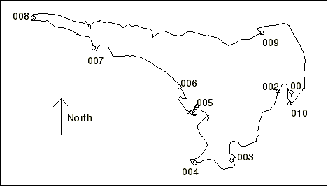
Route Map
Figure 1 shows the track log and waypoints for this ride. As with all the GPS data in this document, the points are fairly accurate, but there are times (especially when the GPS temporarily lost lock on the satellites) when jogs and such appear in the track log that weren't actually on the route.
Route Description
The description below (including linear mileages) is based on where we parked quite close to Ice House Road (about 0.15 miles). I'd recommend going a little farther than I did and finding a good parking spot where you can get fully off the road.
- Mileage 0 (N 38° 55' 41.7", W 120° 23' 12.1", waypoint 001, elv. ~5680) - This is where we parked. Just ride up this dirt road and stay on this main road. (It will be nearly 2 miles before you make your first turn.) This is mostly a steady uphill, granny-gear ride. No killer hills, but good, steady aerobic activity. The terrain from here to the Y junction described below is mostly good dirt road, although a little rocky in a few places.
- Mileage ? (N 38° 55' 42.4", W 120° 23' 20.3", waypoint 002, elv. ~5740) - Stay on the main road here. I believe this mark is just past the junction described in the book as "it [the road] turns south at the first bend and you pass a road with a green gate" near the start of the ride. However, I saw no green gate there. Again, this mark is only for reference, as you stay on the main road here, and continue riding up.
- Mileage 1.41 (N 38° 54' 59.4", W 120° 23' 49.1", waypoint 003, elv. ~6080) - Again, this point is just for reference. There are no junctions here, but we stopped because there is a spectacular view to the east from here. (I think it's a better view than the one from Robbs Peak, although you can't see in all directions like you can from Robbs Peak.) Soon after this, the road curves to the right (west), and you can see Union Valley Reservoir. The road continues up.
- Mileage 1.95 (N 38° 54' 57.4", W 120°
24' 11.8", waypoint 004, elv. ~6320) - Here you reach a Y-Junction, and you
go right, following the sign to "Robb's Hut." Although flat here, the road soon
starts up again. The road from here to Robbs Peak is a bit rockier than the previous
section.
In < 0.5 miles, you come to another green gate that could be closed to prevent cars from going up to Robbs Peak. It was open when we were there, so you could drive the entire way to Robbs Peak. I don't know if this gate is normally open or not. - Mileage 2.96 (N 38° 55' 33.1", W 120°
24' 11.1", waypoint 005, elv. 6686) - This is the location of Robbs Peak.
There is a small parking area here for cars. Robbs Hut is here, which can be rented out
from the Forest Service and/or REI (I forget which), and you should not enter it unless
invited. There is an outhouse here, a picnic table and a BBQ grill, so this would be a
good place for a picnic lunch. And of course, Robbs Peak fire lookout is here (apparently
no longer in use). Take some time here to enjoy the 360° view. (You can walk up on the
deck around the fire lookout.)
When you are ready to continue your ride, continue out on the road past the outhouse. It starts out south, but soon turns north-west. Its downhill from here, but will be steeper in places than what you rode in on. There are enough rocks, loose sticks, etc. on this road that this is a fairly technical section, and you won't be setting any speed records even though it is downhill. - Mileage 3.51 (N 38° 55' 45.4", W 120° 24' 21.6", waypoint 006, elv. ~6400) - You reach a junction where a road takes off to the right, with a sign indicating Robbs Spring to the right. Continue going straight (unless you want to take a detour to Robbs Spring as the book suggests). From here you continue mostly downhill, and the trail continues on the most technical part of this ride as it is rocky and has loose wood on it in places. You will also come to a few dirt mounds in the trail several feet high you will have to stop and walk over.
- Mileage ~4.4 (N 38° 56' 09.7", W 120°
25' 14.8", waypoint 007, elv. ~6140) - No junction here, but you will reach
a section (about 0.1 miles) long that has many large dirt piles across the road, and where
there aren't dirt piles, the dirt is very loose and soft. You will probably walk most or
all of this section, but the regular road does continue at the end of this.
Just before the junction described below, you will reach a Y-fork in the road. Take the right-hand fork for the quickest route to this junction (although the left-hand fork will probably get you to roughly the same junction). - Mileage 5.28 (N 38° 56' 28.4", W 120° 25' 52.4", waypoint 008, elv. ~5920) - You reach a junction with a good dirt road, where you turn right to head back to Ice House Road. As the book describes, going to the left (west) heads towards Georgetown, a private road goes behind you and to your left (south), and by turning right (east) you will head back towards Ice House Road. This is a pretty good dirt road, most of which is downhill, and you should be able to make much better time through most of it than you did the last stretch of road coming down from Robbs Peak.
- Mileage 7.68 (N 38° 56' 19.0", W 120° 23' 30.1", waypoint 009, elv. ~5420) - You reach the junction with Ice House Road. Turn right and continue mostly uphill (not too much granny gear here, however) on the paved road to head back to the road you started on and your car. Remember that you do share this narrow road with cars moving at a good speed.
- Mileage ~8.9 (~N 38° 55' 34.5", W 120° 23' 12.6", waypoint 010, elv. ~5630) - The first junction on your right is the good dirt/gravel road you started on, and you turn onto this road to get back to your car. Remember there is a sign here indicating "Robb's Hut" is down this road, but it is facing traffic coming the opposite way down Ice House Road. How far you have to ride uphill from here depends on where you parked your car along this road.
- Mileage 9.06 - You are now back at the "Mileage 0" point where you parked your car.