Calaveras Big Trees State Park--South Grove Loop
Copyright © 1999 by Jeff Robinson . You are free to use and reproduce this description for personal, not-for-profit, and not-for-business use. Any reproduction other than for personal use, including businesses, organizations, and any other profit making activities require written permission from the author ( jeffs_trails@bigfoot.com , http://www.bigfoot.com/~jeffs_trails ).
Standard Disclaimer: Use this trail description at your own risk . Please see the above web page for safety and other tips.
Introduction
As the name implies, this ride is in Calaveras Big Trees State Park. It is about a 12 mile loop on fire roads through the South Grove of trees. The ride is very pretty as almost the entire ride is through forest (which also provides a lot of shade--nice during the summer). If you have the time, there are also hiking trails available which take you past many of the more spectacular Giant Sequoias in the park.
It is a moderately strenuous ride, with 1200' net elevation gain. In terms of technical difficulty, the ride starts out easy (beginner to advanced beginner), and then reaches some stages of intermediate difficulty as you reach the steeper road with some loose debris across it.
Trail Description Info
This is a set of notes on "Calaveras Big Trees State Park/South Grove Loop," ride 91 on p. 248 of Mountain Biking Northern California's Best 100 Trails by Delaine Fragnoli & Robin Stuart 1 . The notes were taken on 5/29/99 (Memorial Day Weekend). Several items about the ride (total length, road junctions, etc.) didn't look like what I was expecting based on the book description. Either I did a slightly different ride, or the roads have changed a bit since the book was written.
Note that linear mileages are recorded from my bike trip computer. The coordinates come from a hand-held GPS, and accuracy should be considered to around ±400 ft. The elevations (in feet) are taken from USGS topo maps with 40' contour lines (or from TOPO! 2 software versions of these maps, which I highly recommend), and are probably ±40 ft. The "~" symbol means approximately.
Trail Type
This ride is almost entirely on dirt fire road, with a few tenths of a mile of paved road at the start. Essentially the entire ride is through forest, most of which is very tall, dense trees. As a result, this is a very pretty ride, and there is lots of shade (nice for summer rides). There are few signs on the route, but the main fire road is easy to follow, so you should have little doubt about the correct route.
Length/Time
This is about a 12 mile loop, although that can vary a little bit depending on where you start. We spent about 4.5 hours elapsed time on the ride, which included rest time as we rode uphill. The average trip computer speed was 5.2 MPH, and the actual (trip computer) riding time was just over 2 hours 15 minutes.
Difficulty
This is a moderately strenuous ride. It has 1200' net elevation gain (4400-5600'), and nearly 1100' of that is in about 3.2 miles. Although there were a few really steep sections that I walked, most of the uphill riding was sustainable (at least in my condition). If you're in decent shape and are willing to take your time, you can probably handle the uphill.
As for technical difficulty, this ride is almost entirely on fire road with no single track. The first 1.75 miles (which is also the last 1.75 miles) has a little paved road with the rest being good, dirt fire road. Beginners should be able to handle this section just fine.
At about 1.75 miles the road splits and you start the loop. This is where you start about 3.2 miles of serious uphill. The fire road for this loop is in poorer condition. In addition to the steepness, there are a lot of loose pine needles, pine cones, some loose rock, and some ruts from water erosion on the road. Although much of this riding would fall into advanced beginner, some of the steeper sections fall into intermediate (or maybe even advanced intermediate in a few spots) due to the loose debris.
At about 5 miles into the ride you reach the peak of the ride, and the downhill begins. It's mostly downhill the rest of the way out, but there are several granny-gear uphill sections to spoil the downhill just a little bit. (You'll have no trouble making these uphill sections after what you've already ridden.) Again you run into some moderately steep downhill sections with some loose debris, making parts of the return ride intermediate difficulty.
Traffic/Crowds
Since this is a state park, you'll see plenty of people up to the trail head. (Note, however, that the South Grove where this ride is receives much less traffic than the portions of the park nearer the entrance.)
Once we reached the trail head, however, we saw only 4 other mountain bikes the entire ride--and this was on Memorial Day weekend. Thus you can plan on having the ride pretty much to yourself.
Trailhead
Take your favorite route to the town of Angels Camp, and take Highway 4 northeast out of Angels Camp. About 4 miles past the town of Arnold (large enough to have things like Round Table Pizza and Subway) the turnoff for Calaveras Big Trees State Park will be on your right. As of this writing, the entrance fee is $5. From here follow the main road through the park to the South Grove (9 miles, about 25 minutes).
You have at least three choices for places to park:
- The first parking option you come to is the parking lot for the South Grove Trail. This is probably the busiest parking lot.
- If you drive slightly farther, you come to the Beaver Creek Picnic area. This is closer to the trail head, and we found it to be uncrowded. This is where we parked, and the directions will be written assuming you started here.
- Right at the trail head (where the dirt fire road takes off from the paved road), there was enough room to park several vehicles. This saves about 0.3 miles of easy riding on paved roads.
Route Map
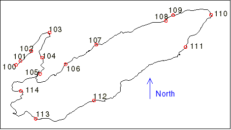
Figure 1 shows the track log and waypoints for this ride. As with all the GPS data in this document, the points are fairly accurate, but there are times (especially when the GPS temporarily lost lock on the satellites) when jogs and such appear in the track log that weren't actually on the route.
Route Description
The description below (including linear mileages) is based on where we parked in the Beaver Creek Picnic Area (at a parking spot nearest the main road). You stay on the main road throughout the ride unless otherwise specified. Distances are given in miles, and elevations in feet.
Unless otherwise noted, trail diagrams drawn below are oriented so you arrive from the bottom. They have no relation to compass directions (up is probably not north). The red arrows show you which way to travel.
- Mileage 0 (N 38° 14' 53.2", W 120° 15' 47.6", waypoint 100, elv. ~4400) - From your parking spot, ride back to the main road.
- Mileage 0.05 (N 38° 14' 56.9", W 120° 15' 43.6", waypoint 101, elv. ~4425) - Turn right on the main paved road and follow it. (The road soon becomes a loop. Stay to the right as the sign directs.)
-
Mileage 0.33 (N 38° 15' 06.1", W 120° 15' 33.7", waypoint 102, elv. ~4425)
- As the paved loop curves up and to the left, you come to a gate with a good dirt road heading off straight in front of you. Take this road.
The road is flat to mild uphill for a ways. The road has a few rocks, but is generally good. After a while, the road will start to drop down to Beaver Creek. - Mileage 0.88 (N 38° 15' 23.0", W 120° 15' 16.9", waypoint 103, elv. ~4440) - You reach a wooden bridge going over Beaver Creek. There was enough water when we were there to make it quite pretty. Continue on the road from here. Lots of steady, low-gear riding, but sustainable. Similar road conditions to before.
- Mileage 1.45 (N 38° 15' 0.0", W 120° 15' 23.8", waypoint 104, elv. ~4570) - A trail crosses the road here. First you see the wide trail (almost a road) heading downhill on your right, and a little bit farther you see the much narrower trail heading uphill on your left. There are clear (but small) signs identifying the trail. Continue riding up the road.
-
 Mileage 1.74 (N 38° 14' 44.9", W 120° 15' 25.5", waypoint 105, elv. ~4620)
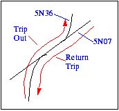
- Just after a road joins from the left, you come to a Y intersection. A couple of faded signs indicate 5N36 to the left and 5N07 to the right. This is the start of the loop portion of the ride. Take the junction uphill to the left. (You will return on the other leg of this Y.)
Mileage 1.74 (N 38° 14' 44.9", W 120° 15' 25.5", waypoint 105, elv. ~4620)
- Just after a road joins from the left, you come to a Y intersection. A couple of faded signs indicate 5N36 to the left and 5N07 to the right. This is the start of the loop portion of the ride. Take the junction uphill to the left. (You will return on the other leg of this Y.)
This is the point where the real uphill starts. You will encounter varying degrees of steepness. There's lots of what I call "turtle-crawl" granny-gear uphill. Some areas are less steep, and a few were steep enough I choose to walk short sections. The road here is also in poorer condition, with lots of pine needles, pine cones, loose sticks, and some ruts from water erosion. There poorer road conditions will remain in varying degrees until you return to this waypoint.
- Mileage 2.48 (N 38° 14' 53.8", W 120° 15' 02.2", waypoint 106, elv. ~4860) - Just before this point the road flattens out a bit, and you even get a little downhill. Soon, however, the uphill starts again, including some "turtle-crawl" and some areas that I walked.
- Mileage 3.04 (N 38° 15' 11.9", W 120° 14' 34.1", waypoint 107, elv. ~5130) - Just before this waypoint the road flattens out, and you enter a clearing of sorts. There are some shorts trees, but not the tall ones you've been in up until now. It looks like a fire came through here at some time in the past. Continue riding, and you'll get a little bit of downhill. Once you pass the "clearing," the forest remains much more sparse and with shorter trees than you had in the first part of the ride.
- Mileage ~3.2 - You start into "turtle-crawl" uphill again. The uphill riding gets quite technical here due to the combination of the loose rock and the steepness. Up until this point I would characterize the technical difficulty as advanced beginner to maybe intermediate, but this part is at least intermediate and probably advanced intermediate.
- Mileage ~3.5 - The road flattens out a bit, and then continues with varying degrees of steepness & difficulty (but nothing like the stretch you just went up).
- Mileage 4.18 (N 38° 15' 33.7", W 120° 13' 30.1", waypoint 108, elv. ~5430) - You start to enter the deep forest with tall trees again. (You've been in lighter forest since Waypoint 107 .) This particular section is in some pretty steep uphill
- Mileage 4.33 (N 38° 15' 39.1", W 120° 13' 23.5", waypoint 109, elv. ~5480) - You crest a hill and start into a little downhill. You're getting near the high-point of the ride, but you're not there yet.
- Mileage 4.53 - The road starts uphill again.
- Mileage 4.93 (N 38° 15' 39.3", W 120° 12' 48.7", waypoint 110, elv. ~5580) - Congratulations. You've made it to the high point of the ride, and get to start into the downhill here. You start out with some significant downhill, and then come to another granny-gear uphill stretch of reasonable length. Take heart, however, as you should have no trouble making it up this uphill stretch after the long climb you did to reach Waypoint 110 .
- Mileage 5.64 (N 38° 15' 09.6", W 120° 13' 12.0", waypoint 111, elv. ~5470) - You crest the granny-gear uphill and start into downhill again. You will continue mostly downhill over the next several miles, but you will encounter several more annoyingly steep uphill sections (not too long though). Remember those steep sections with loose material on the road that made the ride challenging on the way up? You will also run into some steep sections with loose material on the way down, so ride with caution.
- Mileage 7.44 (N 38° 14' 20.5", W 120° 14' 36.1", waypoint 112, elv. ~5180) - A road appears to join here from the left. Continue riding straight ahead.
- Mileage 8.44 (N 38° 14' 03.6", W 120° 15' 29.6", waypoint 113, elv. ~4970) - Another road joins from the left. Continue straight.
- Mileage 9.51 (N 38° 14' 29.1", W 120° 15' 43.3", waypoint 113, elv. ~4600) - Just before this you cross Big Trees Creek. Here a trail crosses the road, with a sign that says "Entering Calaveras South Grove Natural Preserve." You will have mild uphill from the creek, and soon the road changes to mostly flat.
- Mileage 10.20 - You are back to the Y junction at Waypoint 105 . From here, retrace your steps back to the start of the ride.
- Mileage 11.93 - You should now be back at your car at Waypoint 100 where you started the ride.