Dike 8 Trail
Copyright © 1998 by Jeff Robinson . You are free to use and reproduce this description for personal, not-for-profit, and not-for-business use. Any reproduction other than for personal use, including businesses, organizations, and any other profit making activities require written permission from the author ( jeffs_trails@bigfoot.com , http://www.bigfoot.com/~jeffs_trails ).
Standard Disclaimer: Use this trail description at your own risk . Please see the above web page for safety and other tips.
Introduction
This trail is what I describe as fun single track. I believe it is also an excellent trail to take people on for their first experience of single track riding.
This trail is in the Sacramento area on the south shore of Folsom Lake, and goes between the Folsom Point (Dike 8) and Folsom Lake Marina (Brown's Ravine) launch areas.
Trail Description Info
These notes were taken on 9/5/98. This ride is not based on any trail description I've found in any book.
Note that linear mileages are recorded from my bike trip computer. The coordinates come from a hand-held GPS, and accuracy should be considered to around ±400 ft. The elevations (in feet) are taken from USGS topo maps with 20' contour lines, and are probably ±20 ft. The "~" symbol means approximately.
Trail Type
This trail starts out with about a mile of easy dirt road, and the rest of it is fun single track. The dirt road is in full sun, but easy riding. The single-track trail has a quite a bit of shade, which is very nice during the hot summer months.
Length/Time
This is an in-and-out ride. The ride described here is about 3.3 miles one way. We spent about 1.5 hours for the ride, with a trip computer time of 55 minutes actual riding time. However, the trail actually continues quite a few miles past Folsom Lake Marina, so you could make a much longer ride if you wanted to.
Difficulty
This is a great beginner's ride, although most of the more advanced riders I know also have a great time on this trail.
This isn't a very strenuous ride, as it largely follows the lake shore. There are certainly many short sections of up and down (the trail definitely isn't flat), but the longest steep hills are only a couple of hundred feet, and there is no significant elevation change.
In terms of technical difficulty, this is a great learning trail. Most of it is narrow, twisty single track. However, you generally have just weeds and bushes on either side of you (no cliffs or anything), so if you fall off the trail it's no big deal (which is why I think this is a great learning trail). There are plenty of sections that beginning riders will find challenging, and a few sections will probably even challenge intermediate riders. However, these sections are short, so if you do have to walk your bike, you will usually only walk 50-100 feet before you will be back to riding again (which is another reason I think this is a great trail for beginners). Because the trail is fairly twisty, the better riders have fun on this trail because they ride it faster than the beginners. However, this is a heavily used trail, and you will probably meet traffic, so never ride faster than you could see on-coming hikers/bikers (or maybe even a horse).
This is an easy trail to follow, as there are practically no intersections to deal with.
Traffic/Crowds
I wouldn't call this trail crowded, but it is well used, and you will likely meet 5-10 hikers and/or bikers on this trail, with a slim chance of even meeting a horse. No motorized vehicles are allowed on the trails. Since it is twisty single track, never ride faster than you can safely see.
Trailhead
This ride starts from the Folsom Point recreation area on the south side of Folsom Lake. Until about a year ago, this was called Dike 8. A few signs still call in Dike 8, and if you talk to a local person, they will likely also call it Dike 8. (This is also why I call it the Dike 8 trail--it really should be called the Folsom Point trail now.)
To get to Folsom Point from Sacramento, take highway 50 to Folsom. Take the East Bidwell/Scott Road exit, and turn north onto East Bidwell. When you reach Blue Ravine in a couple of miles, turn right. Travel Blue Ravine for several miles, and then turn left onto Natoma St. (by the Albertson's shopping center). (If you're cheap and don't mind a bit of extra uphill, you could park and ride from this shopping center.) After turning onto Natoma St., the entrance to Folsom Point will be on your right in less than half a mile.
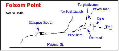
Refer to Figure 1 for finding the trail head within Folsom Point. Drive up the hill and pay your fee at the entrance booth ($6 the last time I checked, unless you have a state parks' season pass). Very soon you will come to a fork in the road, and you stay right towards the picnic area. The road will go uphill and curve to the left. Park in the dirt parking here by the edge of the paved road (a short dirt road takes off to the right).
Route Map
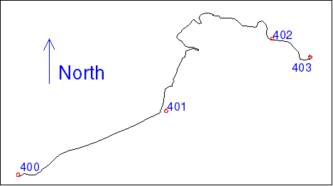
Figure 2 shows the tracklog and waypoints for this ride. As with all the GPS data in this document, the points are fairly accurate, but there are times (especially when the GPS temporarily lost lock on the satellites) when jogs and such appear in the track log that weren't actually on the route.
Route Description
Note that the description I give here marks major junctions. There may be small side trails I don't note. If you come to an unmarked junction, just continue on what appears to be the same, main route you are currently on.
| Mileage 0 (N 38° 41' 42.7", W 121° 07' 39.5", waypoint 400, elev. ~530) - From the parking lot, take the dirt road just east of the paved road. Then through the gate, take the dirt road that heads downhill to the east. (Refer to Figure 1 .) This is probably the longest hill of the whole ride. Soon the road will level out as you reach the Mormon Island Dam. Continue on the road across the top of the dam until you reach the far side. | |
| Mileage 1.12M (N 38° 42' 09.9", W 121° 06' 36.3", waypoint 401, elev. ~480) - At the end of the dam, take the single-track trail that heads straight up the hill, and bear to the left. The trail will generally follow along near the lake shore (high water line). Depending on the time of year, you may have handle-bar high weeds in places. Any challenging places should be fairly short and easy to walk your bike through. As with any area like this, keep your eyes open for Rattle Snakes--if you should find one, just give it plenty of space, and you'll both be fine. | |
| Mileage 2.99M (N 38° 42' 40.8",
W 121° 05' 51.0", waypoint 402, elev. ~510) - A little way before
this, the single-track trail will open up into a road--although the weeds may have grown
high enough that you won't realize it. As you come down a long hill that curves to the
left, a single-track trail will take off to the left just as you clear the trees and can
see the water at Folsom Lake Marina (or lake bed, depending on the water level). When the
water is low enough, I usually take this trail. It is a single-track trail down to a creek
bed, and then a dirt road goes back up to the paved road of Folsom Lake Marina on the
other side of the creek. If the lake level is too high (as it was on the day I took these notes), continue straight ahead on the dirt trail/road. | |
| Mileage 3.35M (N 38° 42' 32.9",
W 121° 05' 34.8", waypoint 403, elev. ~480) - Soon after the
single-track trail curves left next to Green Valley Rd., the dirt single-track trail joins
the paved road near the entrance to Folsom Lake Marina. My trail description for this ride
ends here, but you can pick up the trail again off the paved road farther into the marina,
and continue on the trail for many more miles. The trail past the marina, however, is
often much more challenging than the section described for this ride. From this point, retrace your route back to the parking lot you started from. |