Skyline Ridge Open Space Preserve
Copyright © 1998 by Jeff Robinson . You are free to use and reproduce this description for personal, not-for-profit, and not-for-business use. Any reproduction other than for personal use, including businesses, organizations, and any other profit making activities require written permission from the author ( jeffs_trails@bigfoot.com , http://www.bigfoot.com/~jeffs_trails ).
Standard Disclaimer: Use this trail description at your own risk . Please see the above web page for safety and other tips.
Introduction
This ride is a loop, mostly on single-track trail and dirt road, located in the Skyline Ridge Open Space Preserve by Skyline Blvd. above Palo Alto. On a clear day you can get some nice views from this ride, but as with most trails in these mountains, the ride includes a fair amount of up and down.
Trail Description Info
These notes were taken on 8/8/98. This ride is based on ride 23, "Palo Alto: Skyline Ridge Open Space Preserve" on p. 81 of Bay Area Mountain Bike Trails 1 (©1993) by Conrad J. Boisvert.
Note that linear mileages are recorded from my bike trip computer. The coordinates come from a hand-held GPS, and accuracy should be considered to around ±400 ft. The elevations (in feet) are taken from USGS topo maps with 40' contour lines (or from TOPO! 2 software versions of these maps, which I highly recommend), and are probably ±40 ft. The "~" symbol means approximately.
Trail Type
This route covers mostly dirt roads and single track, although about a mile of the route we took is on a paved, narrow two-lane road that you will have to share with cars.
Length/Time
The ride is mostly a loop, and the route we took was about 5.5 miles. We had about 1 hour of trip computer riding (and a little walking) time, and around 2.5-3 hours total time. (Actually I'm guessing at the total time, because I forgot to record it.)
Difficulty
This ride does have some strenuous parts. The ride starts at about 2250', with a high point of nearly 2500', and a low point of just over 1800'. My hand-drawn route on TOPO! 2 gives a total elevation gain & loss of about 1440', but I suspect that is a little on the high side due to my inaccurate drawing. At any rate, this ride does have several sections of strenuous granny gear where I rested a lot, and one section of several tenths of a mile where I walked. However, not all of the uphill is granny gear, and since the ride is a loop, you have as much down as you do up.
In terms of technical difficulty, this ride isn't too bad. Much of the ride is on dirt road (and even some paved road), and most of those parts I would rate as no worse than advanced beginner. There are some sections of single track, and a few of these areas probably qualify as needing intermediate ability, but that's about as bad as it gets.
This should be a fairly easy route to follow given these directions.
Traffic/Crowds
We certainly weren't alone, but it wasn't crowded either. We probably met a couple of dozen hikers/bikers on the trail during our ride. The route we took put us on about 1 mile of Page Mill Rd., which is a narrow and twisty paved road. You definitely will meet cars you have to share the road with there, so watch/listen carefully for traffic on the paved road.
Trailhead
The trailhead is at the intersection of Page Mill Road and Skyline Boulevard. (Note that the name changes from Page Mill Rd. to Alpine Rd. when it crosses Skyline.) Assuming you are coming from Highway 280, take the Page Mill Road exit in Palo Alto, and head west, staying on Page Mill Rd. all the way to Skyline Blvd. Cross Skyline Blvd., and the parking lot will be almost immediately on your right ( N 37° 18' 55.6", W 122° 11' 17.8", waypoint 250, elev ~2260 ).
Route Map
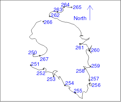
Figure 1 shows the tracklog and waypoints for this ride. As with all the GPS data in this document, the points are fairly accurate, but there are times (especially when the GPS temporarily lost lock on the satellites) when jogs and such appear in the track log that weren't actually on the route. Also, I mistakenly had the track log turned off between waypoints 250->251 and 262->266, so you won't see any connections in those places.
Route Description
Note that the description I give here marks major junctions, but there may be small side roads and trails I don't note. If you come to an unmarked junction, just continue on what appears to be the same, main route you are currently on.
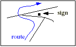
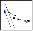
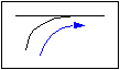
Also note that trail diagrams drawn below are oriented so you arrive from the bottom. They have no relation to compass directions (up is probably not north).
As always, observe the signs, and don't ride your bike on trails closed to bikes. When the trails are wet, it is common to close them to bikes to reduce erosion. (Remember, it only takes a few mountain bikers breaking the rules to close the trails to all mountain bikes, so respect the signs for everyone's good.)
| Mileage 0 (N 37° 18' 55.6", W 122° 11' 17.8", waypoint 250, elev. ~2260) - From the parking lot, cross Alpine Rd. and pick up the single track trail just opposite the parking lot entrance. (Note that the path through the tunnel under the road is closed to bikes.) | |
| Mileage 0.17M (N 37° 18' 46.9", W 122° 11' 20.4", waypoint 251, elev. ~2170) - Cross the bridge, and follow the sign indicating "Ridge Trail Alternate" to the right. Head uphill on the paved road, and you will get a taste of some of the steep granny gear climbing that is ahead of you. | |
 Mileage 0.35M (N 37° 18' 43.9", W 122° 11' 10.1",
waypoint 252, elev. ~2260) - You will arrive at a T intersection. Turn left on
the road, and almost immediately make a sharp right another road. A sign here indicates
that you are continuing to follow the "Ridge Trail (Alternate)," and that it is
1.2 miles to Horseshoe Lake. You will continue to ride varying degrees of uphill on this
dirt road, including sections of granny gear.
Mileage 0.35M (N 37° 18' 43.9", W 122° 11' 10.1",
waypoint 252, elev. ~2260) - You will arrive at a T intersection. Turn left on
the road, and almost immediately make a sharp right another road. A sign here indicates
that you are continuing to follow the "Ridge Trail (Alternate)," and that it is
1.2 miles to Horseshoe Lake. You will continue to ride varying degrees of uphill on this
dirt road, including sections of granny gear. |
| Mileage 0.64M (N 37° 18' 38.1", W 122° 11' 02.1", waypoint 253, elev. ~2400) - You reach an intersection with a road on your left. Go left, following the sign indicating "Ridge Trail (Alternate)" and "Horseshoe Lake 1.0 Mi". The road will continue to climb, giving you lots of steep granny gear, and probably several rest stops (unless you are in much better shape than I'm in). | |
| Mileage 0.85M (N 37° 18' 30.8", W 122° 10' 53.2", waypoint 254, elev. ~2490) - You finally crest the hill at an intersection with a trail taking off and up to the right. Continue straight ahead on the mail trail, and you will soon be going down some fairly steep downhill. | |
| Mileage 1.10M (N 37° 18' 24.7", W 122° 10' 44.8", waypoint 255, elev. ~2300) - You will come to a 4-way intersection. Continue on the road straight ahead and downhill, following the sign indicating "Horseshoe Lake 0.5 Mi". The steep downhill continues. | |
 Mileage 1.52M (N 37° 18' 32.1", W 122° 10' 33.3",
waypoint 256, elev. ~2060) - You reach another intersection. Continue straight
ahead on the road, following the sign indicating "Skyline Parking 0.2M". (If you
turned right, the road would take you on a loop around Horseshoe Lake.)
Mileage 1.52M (N 37° 18' 32.1", W 122° 10' 33.3",
waypoint 256, elev. ~2060) - You reach another intersection. Continue straight
ahead on the road, following the sign indicating "Skyline Parking 0.2M". (If you
turned right, the road would take you on a loop around Horseshoe Lake.) |
| Mileage 1.61M (N 37° 18' 35.0", W 122° 10' 33.7", waypoint 257, elev. ~2040) - You reach an equestrian parking lot. Pick up the single track trail on the far left of the parking lot. | |
| Mileage 1.81M (N 37° 18' 43.9", W 122° 10' 37.3", waypoint 258, elev. ~2070) - You reach the main parking lot. Follow the dirt road out of the main lot. After about 0.1M, you will see a trail on your left. Take this trail, and cross Skyline Blvd. | |
| Mileage ~1.9M (N 37° 18' 46.1", W 122° 10' 32.7", waypoint 259, elev. ~2100) - As soon as your cross Skyline, you should be facing a gate marked "MB06." Follow the trail to the left marked "Skid Road Trail" and "To White Oak Trail 0l4 Mi". You will be riding downhill, mostly on dirt road. | |
| Mileage 2.33M (N 37° 18' 58.6", W 122° 10' 33.5", waypoint 260, elev. ~1880) - You reach a gate, with a single-track trail taking off to the left. If you were to follow the route in Bay Area Mountain Bike Trails , you would continue straight here (downhill on the dirt road). However, when we were there, a sign was posted indicating no bicycles past that gate (even though the gate was open), so we honored the sign and took the single track to the left, which continues taking you downhill. I would describe this single track as "fun", as it isn't too steep or technical in most spots, although it does have a few sharp turns. | |
| Mileage 2.60M (N 37° 19' 04.0", W 122° 10' 41.1", waypoint 261, elev. ~1820) - You cross a bridge to go over a stream, and your downhill is over for a while. You start out uphill on single track with gentle granny-gear riding. | |
| Mileage ~3.0M - The single-track trail opens up into a much wider dirt road, but it also gets much steeper here. I was tired enough that I took to walking this section rather than riding it. | |
| Mileage ~3.3M - The road becomes less steep, and I started riding most sections again. | |
| Mileage 3.56M (N 37° 19' 26.2", W 122° 11' 05.3", waypoint 262, elev. ~2270) - You reach a T intersection. A sign indicates "White Oak Trail, -> To Monte Bello Parking 0.3Mi, <- To Alpine Rd. 0.2 Mi". Go right, and the dirt road will take you gently uphill. | |
| Mileage 3.71M (N 37° 19' 29.7", W 122° 10' 59.1", waypoint 263, elev. ~2300) - You crest the hill, and the road starts downhill. | |
 Mileage 3.87M (N 37° 19' 33.5", W 122° 10' 53.7",
waypoint 264, elev. ~2250) - You meet a dirt road that is parallel to Page Mill
Rd. (Actually it looked more like a fire break than a traditional dirt road.) Stay right
and downhill, parallel to Page Mill Rd.
Mileage 3.87M (N 37° 19' 33.5", W 122° 10' 53.7",
waypoint 264, elev. ~2250) - You meet a dirt road that is parallel to Page Mill
Rd. (Actually it looked more like a fire break than a traditional dirt road.) Stay right
and downhill, parallel to Page Mill Rd. |
| Mileage 3.98M (N 37° 19' 33.4", W 122° 10' 47.8", waypoint 265, elev. ~2230) - We choose to stop here, just short of reaching the Monte Bello parking area. The Los Trancos parking area is just across Page Mill Rd. from here, which has trails that will take you up close and personal with the San Andraes Fault. We turned around here, and retraced our steps back to the intersection at waypoint 262 . | |
| Mileage 4.41M (N 37° 19' 26.2", W 122° 11' 05.3", waypoint 262, elev. ~2270) - Now that you have reached waypoint 262, you have three options: | |
| You can turn left, and retrace your steps all the way back. | |
| You can turn left, and retrace your steps to Skyline Blvd. at waypoint 259 . Turn right and ride north on Skyline until you reach the Page Mill Rd./Alpine Rd. intersection at waypoint 267. | |
| You can continue riding straight, which will soon drop you onto Page Mill Rd. for the return ride. The remaining description here assumes you are continuing straight to Page Mill Rd. | |
| Mileage 4.52M (N 37° 19' 21.9", W 122° 11' 10.3", waypoint 266, elev. ~2250) - You reach a gate at Page Mill Rd. after going through a dirt/grass parking lot. Turn left and ride on Page Mill, being cautious to pay attention to cars on this narrow and twisty paved road. You will start out riding downhill, and then change to uphill, but there is no granny gear riding. | |
| Mileage 5.35M (N 37° 18' 54.5", W 122° 11' 13.2", waypoint 267, elev. ~2290) - You reach the Skyline Blvd. junction. Continue straight across and the name changes from Page Mill Rd. to Alpine Rd. In a couple of hundred yards you will turn right into the parking lot. | |
| Mileage 5.47M (N 37° 18' 55.6", W 122° 11' 17.8", waypoint 250, elev. ~2260) - You're back in the parking lot where you started. |