West Side Rails Trail
Copyright © 1999 by Jeff Robinson . You are free to use and reproduce this description for personal, not-for-profit, and not-for-business use. Any reproduction other than for personal use, including businesses, organizations, and any other profit making activities require written permission from the author ( jeffs_trails@bigfoot.com , http://www.bigfoot.com/~jeffs_trails ).
Standard Disclaimer: Use this trail description at your own risk . Please see the above web page for safety and other tips.
Introduction
This is a mostly easy ride along the old West Side Railroad bed, located in the Sierra above Sonora. Unlike most of the mountain bike trails in the Sierra, the entire trail is essentially flat (no significant elevation change), and riding along the old rail bed is quite easy. This is a good trail to take people on who like the outdoors but aren't experienced mountain bike riders.
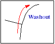
There are a few short places where the old rail bed has washed out or where logs and rocks have fallen over the trail that are more technical, but with the exception of those few places, this is a ride to just enjoy the scenery. (If you're in the mood for a technical ride, this isn't the ride to take.)
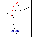
One note of caution: we rode this very late in the summer, and there were several stream crossings. The first one looked like it would be very difficult if not impossible to cross if there were significantly more water (and is just above a 20-30' or so water fall, so you wouldn't want to get swept away). Thus this is probably not a spring or early summer ride.
Trail Description Info
These notes were taken on 9/19/98. This ride is described in "West Side Rails," p. 90 of Rail Trail Guide to California by FredWert 1 . There are about 5 miles of dirt road to drive on to get to the trail head. When I was there, the roads were in good shape, and I don't think cars would have trouble making the drive.
Note that linear mileages are recorded from my bike trip computer. The coordinates come from a hand-held GPS, and accuracy should be considered to around ±400 ft. The elevations (in feet) are taken from USGS topo maps with 40' contour lines (or from TOPO! 2 software versions of these maps, which I highly recommend), and are probably ±40 ft. The "~" symbol means approximately.
Also note that the routes shown on topo maps came from TOPO!GPS software. The track logs came from a Garmin GPS 12XL and were loaded directly from the GPS. Thus at times the routes on the topo maps may not line up exactly with the corresponding trails on the maps.
Trail Type
This trail follows an old railroad bed, and has essentially no elevation change. The trail is quite easy to follow. Most of the trail is wide and can best be described as a dirt road. There are a few short sections that have washed out that are single track or stream crossings with no trail. You will probably meet few if any motorized vehicles on this trail.
Length/Time
This is an in-and-out ride that would be 9-10 miles each way (18-20 miles total) if you rode the whole ride. Due to time constraints, we rode in only 6 miles (12 mile round trip), with an elapsed time of 3 hours. I didn't record the trip computer time, but it was probably about 2 hours.
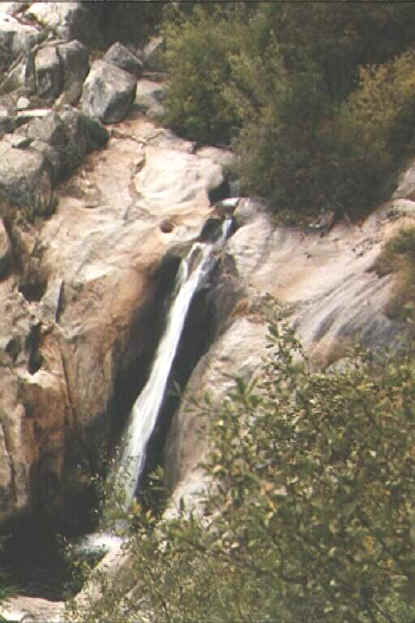
Figure 1: A waterfall just below the stream crossing of waypoint 209
Difficulty
This is one of the easiest mountain bike rides I have been on in a long time. The trail has virtually no elevation change, so it is not a strenuous ride at all. There are a few washed out sections of trail where you will need to walk your bike up or down some short, steep areas, but otherwise this is about as flat as it gets.
In terms of technical difficulty, most of the ride is again quite easy, with most of it falling into a beginner or perhaps advanced beginner category. In fact, you could probably pull a kid in a bicycle trailer over 90% of the trail. However, there are some washed out areas that due to steepness and loose dirt or rock make for either technical riding or walking (so definitely leave the trailer behind). There are also a few areas with fallen rock or trees on the trail that raise the riding difficulty to advanced beginner or intermediate (although they are short enough you could easily walk through them in a few minutes).
This is a pretty easy trail to follow. (The toughest part is getting to the trail head in the first place.) There aren't many signs, but if you're good at following directions, you should have no problem.
Traffic/Crowds
We saw quite a few vehicles on the dirt roads while driving in, but saw no other bikes or walkers on the trail itself. We met a 4x4 at one place on the road, and clearly other off-road vehicles had been on part of the trail, but that's all we saw, so I wouldn't plan on meeting many people on this ride.
Trailhead
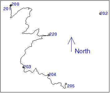
I found reaching the trail head to be the most challenging part of this ride, so I've included a tracklog and waypoints to help reach the trail head in Figure 2 . Note that I marked some of the waypoints on the way out, so they aren't always in numerical order.
Figure 2 : Tracklog and Waypoints for road from Long Barn to the trail head
- Head north on highway 108 out of Sonora to the town of Long Barn (about 20 minutes out of Sonora).
- (N 38° 06' 00.6", W 120° 07' 21.9", waypoint 200, elev. ~5050) - There are two exits from 108 to Long Barn, both on your right. I suggest taking the second exit (about 1.2 miles past the first exit), and waypoint 200 is at this second exit. However, either exit can get you to road 3N01.
- (N 38° 05' 58.7", W 120° 07' 24.0", waypoint 201, elev. ~5030) - Turn left onto Forest Service road 3N01, which you will come to in a couple tenths of a mile after you exit highway 108. It took us about 45 minutes to get from here to the trailhead at waypoint 205 .
- (N 38° 04' 24.8", W 120° 05' 19.5", waypoint 220, elev. ~5590) - In approximately 6 miles you will turn right onto 3N07. There is a sign here that says "West Side Rail Tour, 5-->". (If you miss seeing the sign like I did, you will eventually come to Hull Creek campground, which is waypoint 202 on the map.) The pavement will end soon after this, and the rest of your drive will be on dirt roads. The roads were in good shape when I was there, and I don't think cars would have trouble making the drive.
- (N 38° 02' 40.0", W 120° 06' 42.5", waypoint 203, elev. ~5335) - In about 3 miles you will come to a major fork in the road. Take the left-hand fork, following the sign that says "West Side Rail Tour, 2 Mi <--".
 (N 38° 02'
15.0", W 120° 05' 21.3", waypoint 204, elev. ~5100) -
(N 38° 02'
15.0", W 120° 05' 21.3", waypoint 204, elev. ~5100) -
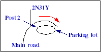
In about 2 miles, you will come to what is probably the official start of this trail. A road takes off up and to the left labeled 2N31Y. On your right is a small dirt parking lot with a large (8x8"?) interpretive marker post with a number "2" on it. (You will come across a number of interpretive marker posts like this on the ride, which I will just call "post 2" from now on.) However, I continued driving another 2 miles (on the main road curving to the right) to waypoint 205 before I started the ride.
 (N 38° 01'
46.0", W 120° 04' 24.8", waypoint 205, elev. ~5100) -
(N 38° 01'
46.0", W 120° 04' 24.8", waypoint 205, elev. ~5100) -
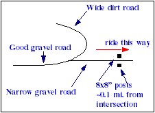
In about 2 more miles you come to what I used as the start of the trail head. The wide, good gravel road you are on makes almost a U-turn up and to the left, and becomes a wide dirt road. Straight ahead is a much narrower gravel road. Find a wide place to park here and start your ride. (Note: unlike most of my diagrams, you arrive from the left of this diagram rather than the bottom.)
Route Map
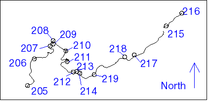
Figure 3 shows the tracklog and waypoints for this ride. As with all the GPS data in this document, the points are fairly accurate, but there are times (especially when the GPS temporarily lost lock on the satellites) when jogs and such appear in the track log that weren't actually on the route.
Route Description
Because this whole ride is essentially flat, I won't list elevations for each waypoint. The entire ride is at essentially 5100'.
Unless otherwise noted, trail diagrams drawn below are oriented so you arrive from the bottom. They have no relation to compass directions (up is probably not north). The red arrows show you which way to travel.
Also note that I marked some of the waypoints on the return trip, so not all waypoints will be in numerical order.
- Mileage 0 (N 38° 01' 46.0", W 120° 04' 24.8", waypoint 205) - Ride straight ahead on the narrow gravel road. In about 0.1 miles you will come to a pair of 8x8" posts on either side of the road, so you will know you're in the right place. Note that from here up to waypoint 208 the road is quite good, and you will likely see signs of off-road vehicles through here.
 Mileage 0.80M (N
38° 02' 17.8", W 120° 04' 16.8", waypoint 206)
Mileage 0.80M (N
38° 02' 17.8", W 120° 04' 16.8", waypoint 206)
- You will cross a small stream that runs across the road, along with a couple of pipes. Immediately after this a road takes off uphill to the left, and soon after another fork takes off downhill to the right. Continue riding straight on the level bed.
 Mileage 1.47M (N
38° 02' 33.3", W 120° 03' 57.9", waypoint 207)
Mileage 1.47M (N
38° 02' 33.3", W 120° 03' 57.9", waypoint 207)
- A road takes off uphill to the left. Continue on the main bed which curves right through a partial washout.
- Mileage 1.58M (N 38° 02' 39.6", W 120° 03' 54.4", waypoint 208) - Another road takes off and up to the left. Continue ahead on the level bed.
- Mileage 1.65M (N 38° 02' 35.7", W 120° 03' 54.3", waypoint 209) - You come to a good size stream which you have to cross. (This waypoint is actually after you cross the stream.) We were here in September at the end of the summer. If the water had been a little higher, we would have gotten our feet wet crossing this stream. If it were a lot higher, we probably couldn't have made it across at all. (There is a good size water fall just below this, so you definitely wouldn't want to get caught in a current here.) From here on only two-wheel vehicles will make it down the trail (no more 4x4s), and the trail condition here isn't quite as good as it was before the stream.
- Mileage 1.98M (N 38° 02' 27.4", W 120° 03' 39.5", waypoint 210) - The bed turns into a trail for a little way and crosses another stream. This is a significant stream, but nothing like the last one. After crossing the stream, you will have about 0.1 miles of the bed very rocky. Then it improves, but you will continue to find short sections of the bed strewn with rocks, downed trees, and branches.
- Mileage 2.42M (N 38° 02' 14.6", W 120° 03' 37.9", waypoint 211) - You come to another stream to cross. Again you will have 0.1-0.2 miles of rocky bed after the crossing, but then the bed will improve into a pretty good road.
 Mileage 3.01M (N
38° 02' 02.3", W 120° 03' 30.6", waypoint 212)
Mileage 3.01M (N
38° 02' 02.3", W 120° 03' 30.6", waypoint 212)
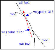
- The rail bed joins a good dirt road for a short distance.
- Mileage 3.07M (N 38° 02' 02.9", W 120° 03' 26.5", waypoint 213) - The level rail bed again takes off straight ahead as the main dirt road curves to the left.
- Mileage 3.15M (N 38° 02' 00.7", W 120°
03' 22.8", waypoint 214) - A road (jeep trail?) comes from the left
(uphill), and probably continues on the right (downhill). Continue straight and flat.
Note that from here on the trail is mostly very easy riding. It's flat and smooth with few sticks or rocks, so you should be able to make good time through here. - Mileage ~3.52M (N 38° 01' 59.0", W 120° 03' 05.8", waypoint 219) - You will pass a marker post (post 7?).
- Mileage ~4.32M (N 38° 02' 20.3", W 120° 02' 29.7", waypoint 218) - You pass another marker post (post 8 or 9).
- Mileage ~4.55M (N 38° 02' 22.6", W 120° 02' 18.4", waypoint 217) - You reach marker post 10.
- Mileage 5.59M (N 38° 02' 57.3", W 120° 01' 40.8", waypoint 215) - You reach marker post 11.
- Mileage 5.99M (N 38° 03' 12.5", W 120°
01' 22.2", waypoint 216) - Here you come to interpretive marker post 12,
along with some 1" cables running across the road.
We were running out of day, so this is as far as we rode. It should be easy to follow the trail on from here. Where ever you turn around, just retrace your steps for the return trip.