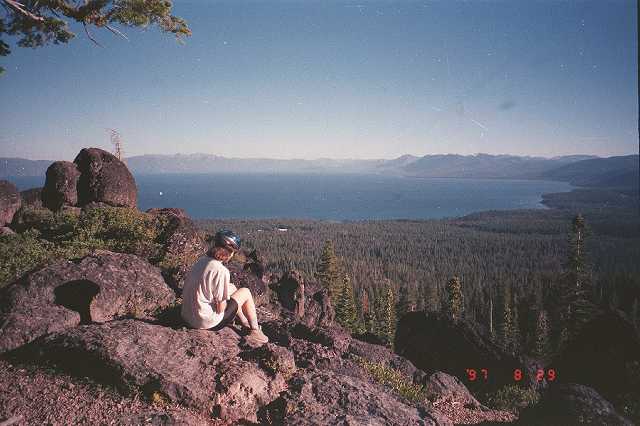
Watson Lake from Tahoe
City High School
Copyright © 1998
by Jeff Robinson . You are free to use and reproduce this description for
personal, not-for-profit, and not-for-business use. Any reproduction other than for
personal use, including businesses, organizations, and any other profit making activities
require written permission from the author ( jeffs_trails@bigfoot.com , http://www.bigfoot.com/~jeffs_trails ).
Standard
Disclaimer: Use this trail description at your own risk . Please see the above
web page for safety and other tips.
Introduction
The ride from Watson Lake out to the
"Lava Rocks" is a fun, single-track ride, and the view of Lake Tahoe from the
Lava Rocks is spectacular. However, there are many ways to get to Watson Lake and the
"lava rocks." This ride describes a loop from Tahoe City, which includes a lot
of climbing on dirt roads to get to the top, and some technical single-track downhill to
get to back.
Trail Description Info
There are many rides that go to Watson Lake,
as it is in part of the North Star Trail System. These notes were taken on 8/29/97 (Friday
before Labor Day). This ride up is based on the "Ride #3 - Watson Lake Loop," p.
81 of Mountain Biking The High Sierra, Guide 3B: Lake Tahoe - North (1992
edition, I believe a newer edition is now available) by Carol Bonser. The route we took
back down is not described in any book I have come across.
Note that linear mileages are recorded from my
bike trip computer. The coordinates come from a hand-held GPS, and accuracy should be
considered to around ±400 ft. The elevations (in feet) are taken from USGS topo maps with
40' contour lines. The "~" symbol means approximately. The "+" symbol
means it was a bit above this contour line elevation, and the "-" symbol means
it was a bit below this contour line elevation.
Trail Type
This route covers both dirt roads and single
track. Difficulty covers a wide range, including good dirt roads, very rocky dirt roads,
fairly easy single track, and very challenging single track.
Length/Time
This is about a 13 mile loop. Due to some
technical walking parts (not helped by the fact we rode late in the season which made for
very loose dirt in the steep parts), our elapsed time was 5 hours 10 minutes (including a
quick lunch, but not a lot of sight seeing). Trip computer riding time was 2 hours 23
minutes, with an average speed of 5.4 MPH.
Difficulty
This ride has about 1300' of elevation gain
with lots of granny gear riding, but not too many "killer hills". Thus this is a
fairly strenuous ride, but many rides in the Tahoe area are much more severe.
In terms of difficulty, I would classify the
majority of the ride in (and up) as advanced beginner. However, there are several sections
that are at least intermediate, and a little bit that you will walk up (unless you are an
advanced rider in great shape). Much of the ride out (and down), however, qualifies as
intermediate with a lot of walking or advanced due to steep downhill single-track with
loose dirt and rock. However, this ride could be done as an in-and-out, which would avoid
most of the real technical stuff.
Most of this ride should be pretty easy to
follow with these directions. However, the last little part of getting back to the high
school can get confusing, as there are many junctions. To further make things difficult,
my notes for the last little bit are very sketchy, largely because we were following
another rider out who knew the trails and I didn't have a chance to take waypoints.
Traffic/Crowds
This is typical Tahoe mountain biking: you'll
probably see quite of mountain bikes and tracks on the route in. You may also see some
motorized vehicles (cars, trucks, motorcycles, etc.) on some of the roads in.
Trailhead
I'll quote from the book for this. The book
assumes you might want to ride to here. We drove.
In Tahoe City, start from the intersection of Highway 89 and Highway 28. Ride or drive
northeast on Highway 28 through the main part of town. Turn left (northwest) on Old Mill
Road, and after about a half mile, turn left again on Polaris at the top of the hill.
Continue 0.4 mile farther to the end of the pavement just past North lake Tahoe High
School. If you drove to this point, park here out of the way of the school traffic.
We parked at the end of the pavement next to
the high school parking lot (N 39° 11' 37.2", W 120° 07'
18.0", waypoint 050, elev. ~6600-) .
Route Description
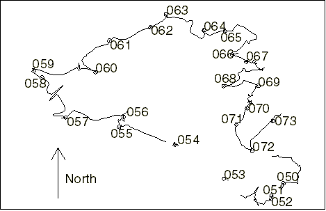
Note that the description I give here marks
major junctions, but there are many small side roads and trails I don't note. If you come
to an unmarked junction, just continue on what appears to be the same, main route you are
currently on.
Also note that trail diagrams drawn below are
oriented so you arrive from the bottom. They have no relation to compass directions (up is
probably not north).
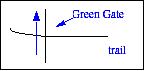
 | Mileage 0 (N 39° 11' 37.2", W 120°
07' 18.0", waypoint 050, elev. ~6600-) - From the end
of the pavement, continue on the dirt road past the green gate. Stay right at the junction
you come to almost immediately. (The right fork was freshly covered with wood chips when
we were there.) |
| Mileage 0.15M - You come to a sign
that says "Burton State Park". |
| Mileage 0.32M (N 39° 11' 28.3", W 120°
07' 26.6", waypoint 051, elev. ~6520) - You go through
another green gate. |
| Mileage 0.39M (N 39° 11' 26.1", W 120°
07' 26.8", waypoint 052, elev. ~6520+) - Turn right when you T into another
dirt road. This stretch of the ride is slightly rough, but fairly level. |
|  Mileage 1.03M (N 39° 11' 40.4", W 120° 08' 00.9", waypoint
053, elev. ~6600+) - You join another dirt road. Continue
straight. This section of the ride isn't too steep, but many rocks and loose dirt make
this section fairly technical. Mileage 1.03M (N 39° 11' 40.4", W 120° 08' 00.9", waypoint
053, elev. ~6600+) - You join another dirt road. Continue
straight. This section of the ride isn't too steep, but many rocks and loose dirt make
this section fairly technical. |
| Mileage ~1.6M - When you reach this
point in the road, you'll trade in most of the technical rocks and soft dirt for
granny-gear uphill. |
|  Mileage 1.84M (N 39° 12' 04.8", W 120° 08' 36.1", waypoint
054, elev. ~6800) - You come to a 4-way junction with a
green gate straight ahead. (The road right turns into a trail.) A tree next to the gate
has an "8" on it and is marked "Antone Natural Preserve Area".
Continue straight ahead past the gate. This section of the ride is fairly easy and level. Mileage 1.84M (N 39° 12' 04.8", W 120° 08' 36.1", waypoint
054, elev. ~6800) - You come to a 4-way junction with a
green gate straight ahead. (The road right turns into a trail.) A tree next to the gate
has an "8" on it and is marked "Antone Natural Preserve Area".
Continue straight ahead past the gate. This section of the ride is fairly easy and level. |
| Mileage 2.56M (N 39° 12' 17.7", W 120°
09' 16.3", waypoint 055, elev. ~6840) - You come to a T-intersection. Go
right up the steep, uphill single track, with rocks and loose dirt. Good riders in good
condition could probably ride much of this. We walked. (You gain about 120' in about
0.2M.) |
| Mileage 2.75M (N 39° 12' 25.0", W 120°
09' 13.0", waypoint 056, elev. ~6960) - You come to a T-intersection with a
single-track trail. A passing rider told us the route to the right goes back to the high
school (perhaps via waypoint 054 ?
I'm just guessing). Go left to continue this ride. This section of trail is fun, rideable
single-track, although there is quite a bit of granny gear. |
| Mileage ~3.1M - The trail crests, and
it is mostly downhill or flat from here. |
| Mileage 3.55M (39° 12' 24.3", W 120°
09' 54.5", waypoint 057, elev. ~7120) - Here you T with a hairpin curve in
dirt road 16N73. A sign behind you indicates the trail you just came off of is
"73E". Go uphill to the right, starting a long, steady, granny-gear hill climb.
Other than some soft dirt in the turns and the uphill, this section of ride is easy. |
| Mileage 4.39M (N 39° 12' 53.1", W 120°
10' 11.7", waypoint 058, elev. ~7400-) - The marked Tahoe Rim trail crosses
the road here. Continue the granny-gear uphill on the road. |
| 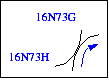 Mileage 4.55M (N 39° 12' 57.8", w 120° 10' 17.7", waypoint
059, elev. ~7400) - A road joins from the left as the road you are on curves to
the right. If you look closely, you discover it is actually two roads, with the one to the
left labeled 16N73H, and the one on the right labeled 16N73G. Continue up the road you are
on for more granny-gear climbing. Mileage 4.55M (N 39° 12' 57.8", w 120° 10' 17.7", waypoint
059, elev. ~7400) - A road joins from the left as the road you are on curves to
the right. If you look closely, you discover it is actually two roads, with the one to the
left labeled 16N73H, and the one on the right labeled 16N73G. Continue up the road you are
on for more granny-gear climbing. |
|  Mileage
5.29M (N 39° 12' 57.0", W 120° 09' 33.1", waypoint 060, elev. ~7600+)
- The road you are on curves to the left while another road joins from the right. Continue
the granny-hear climbing up and left on the road you are on. Mileage
5.29M (N 39° 12' 57.0", W 120° 09' 33.1", waypoint 060, elev. ~7600+)
- The road you are on curves to the left while another road joins from the right. Continue
the granny-hear climbing up and left on the road you are on. |
| Mileage 5.99M (N 39° 13' 19.6", W 120°
09' 23.1", waypoint 061, elev. ~7800-) - Road 73E
joins from the right, which goes up to very near the peak of Mt. Watson. (A nice ride if
you have the energy, but much of the road is quite steep. It was granny-gear plus frequent
stops the last time I rode it.) A sign pointing the other way indicates "Tahoe
City" where you just came from. Continue ahead on the road you have been riding on.
The good news is that you are near the top of your ride, and it is fairly flat from here. |
|  Mileage
6.51M (N 39° 13' 29.2", W 120° 08' 53.7", waypoint 062, elev. ~7800-)
- You join another road (at a curve in the other road). Where you just came from has a red
sign "End of North Star Trail System." (Essentially all the red signs in this
area are North Star trail signs.) Continue up and right (actually more straight) on the
road (not down and left) past the red diamond "100" sign. Mileage
6.51M (N 39° 13' 29.2", W 120° 08' 53.7", waypoint 062, elev. ~7800-)
- You join another road (at a curve in the other road). Where you just came from has a red
sign "End of North Star Trail System." (Essentially all the red signs in this
area are North Star trail signs.) Continue up and right (actually more straight) on the
road (not down and left) past the red diamond "100" sign. |
| Mileage 6.77M (N 39° 13' 38.6", W 120°
08' 42.5", waypoint 063, elev. ~7800+) - You come to a road at a 90° angle
entering from the right, with a sign indicating Watson Lake is down that road. Take that
road to Watson Lake. This part of the ride is mostly downhill, but with some uphill. |
| Mileage 7.49M (N 39° 13' 27.1", W 120°
08' 15.2", waypoint 064, elev. ~7800-) - You've reached Watson Lake. This is
a nice place to enjoy the view, eat lunch, etc. When you're ready to continue, continue on
the road. It's pretty faint right here at the lake as it winds up through some rocks (not
many vehicles, even 4x4's, could make it through here). Soon, however, you rejoin a
recognizable road that heads mostly downhill. |
| Mileage 7.79M (N 39° 13' 26.4", W 120°
08' 00.0", waypoint 065, elev. ~7720) - Watch for a marked single-track
trail to the right and take it. (Don't go too quickly down the hill, or you might ride
right past this trail.) You are starting on a single-track trail that is moderately
technical in some places, and that has some granny-gear uphill. This is also where the
ride leaves the book description. |
| Near the top of your climb, you come to a 4-way trail junction. The
trail coming down-hill from the right is coming from the top of Mt. Watson. (This is where
you would come in if you had taken the road at waypoint 061 .)
The trail down and left is blocked off with logs and such. Continue straight ahead and
somewhat up on the middle trail. |
| Mileage 8.58M (N 39° 13' 09.5", W 120°
07' 54.9", waypoint 066, elev. ~7880-) - Fairly soon after the trail starts
to drop gently downhill, the trail makes a hairpin curve to the left and starts to drop
more steeply downhill. Due to some rocks and loose gravel, this is a moderately technical
downhill ride (and quite technical if you come up this). |
| Mileage 8.74M (N 39° 13' 04.5", W 120°
07' 44.8", waypoint 067, elev. ~7680) - Look to your
right for some large lava rock next to a cliff. The view from here is spectacular, with a
great view of almost all of Lake Tahoe on a clear day. This has been the destination of
many of our rides, and to avoid the really technical downhill, turn around here to do an
out-and-back.
To continue on this loop, continue down the trail from here. You will find lots of
technical sections, with various combinations of steep downhill, curves, rocks, and loose
dirt. |
| Mileage ~9.4M - The single-track
trail becomes a bit more rideable from here. |
|  Mileage
9.65M (N 39° 12' 47.0", W 120° 08' 01.0", waypoint 068, elev. ~7360 ) - You come to a single-track trail junction, with a sign
indicating you were on the Tahoe Rim Trail. Take a sharp left and continue downhill on
fairly easy, rideable single-track. Mileage
9.65M (N 39° 12' 47.0", W 120° 08' 01.0", waypoint 068, elev. ~7360 ) - You come to a single-track trail junction, with a sign
indicating you were on the Tahoe Rim Trail. Take a sharp left and continue downhill on
fairly easy, rideable single-track. |
| Mileage 10.05M (N 39° 12' 47.2", W 120°
07' 36.1", waypoint 069, elev. ~7240+) - You come to a junction with a trail
on your right. The trail ahead was blocked off with a log when we came to it (but logs can
move with time). Take the trail down and right. This is another technical section that is
fairly steep with lots of loose dirt. We walked quite a bit of it. |
| Mileage 10.45M (N 39° 12' 31.0", W 120°
07' 44.1", waypoint 070, elev. ~6920-) - You come to a T-intersection with
choices of left (and a bit up) or down (and a bit right). Go down and right. The rest of
the ride is mostly rideable on roads. |
| Mileage 10.67M (N 39° 12' 19.5", W 120°
07' 51.8", waypoint 071, elev. ~6840) - You come to another T-intersection
with a dirt road. Go left and slightly down. |
| 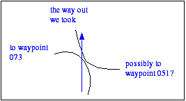 Mileage 10.99M (N 39° 12' 00.7", W 120° 07' 40.5", waypoint
072, elev. ~6840) - Unfortunately this is where the clear directions end. You
come to a 4-way junction in the road that doesn't have an exact match on the USGS topo map
(revised 1992). Mileage 10.99M (N 39° 12' 00.7", W 120° 07' 40.5", waypoint
072, elev. ~6840) - Unfortunately this is where the clear directions end. You
come to a 4-way junction in the road that doesn't have an exact match on the USGS topo map
(revised 1992).
We started out taking the left-most route (which is the continuation of the road you are
on), and rode a ways past waypoint 073 (Mileage 11.33+, N 39°
12' 21.9", W 120° 07' 25.4", waypoint 073, elev. ~6800-) , but it didn't look like it was going where we wanted, and a passing
rider confirmed this.
My guess is that taking the right-most route would eventually take you back to waypoint 053 , but I can't be sure since we didn't take that
route.
What we did do was follow another ride out through the "middle" of the two forks
(more or less straight ahead on the other road), as indicated on the diagram. We continued
on the most significant road past at least one notable junction (road joins on the right,
we stayed left--the topo map suggests this road might go back to near waypoint 051 ). A bit further, we came to another significant
junction where the road we were on continued more or less straight, and we took the road
down to the right. A bit farther on, a somewhat faint trail took off to the right of the
road. We took this trail to the right, and quite quickly (probably within a tenth of a
mile) the high school appears. Continue on the trail around the field to the parking lot,
and head back to your starting point. |
| Mileage ~13.12M - You should now be
back where you started at waypoint 050 .
Note that the mileage here includes our detour past waypoint 073 ,
so if you do things right your mileage should be lower. |